how pre-emptive fire treatment affects wildfires
Spatial and temporal analysis of the Rodeo-Chediski fire using MODIS and Lansat imagery and vegetation regrowth (NDVI).
Analysis Description
As part of the Southwest Climate Adaptation Science Center, I took part in a collaborative research fellowship. Working with a group of 7 other fellows, we analyzed the relationship between fire and society. Throughout our analysis, we learned about the role that fire plays for ecosystem health and culture from the standpoint of indiginous people. We also applied a more quantitative assessment of climate change trends and the impacts of fire treatments. In this project, my main contribution was through analysis of the Rodeo-Chediski fire, where I analyzed the spatial and temporal impacts of pre-emptive perscribed burns as wildfire treatment techniques.
The Rodeo-Chediski Fire
The wildfire, which burned 462,600 acres between June 18 and July 7, 2002, was the culmination of two human-induced ignitions. The prolonged drought during that time period enhanced the spread of the fire across the Mogollon Rim; a high elevation and forested region of Arizona.
At the time of the fire, the Rodeo-Chediski fire was the largest and most destructive fire in Arizona’s history.
Consequences of the fire include:
- Destruction of 500 homes, evacuation of 30,000 people.
- Decrease of soil infiltration rates up to 3 years post-fire, causing peak storm flows of historical magnitude.
- In high-severity burn areas, ~75% of pre-fire trees died within 3 years post-fire.
- Less than 5% of pre-fire trees died in areas of low-severity burns.
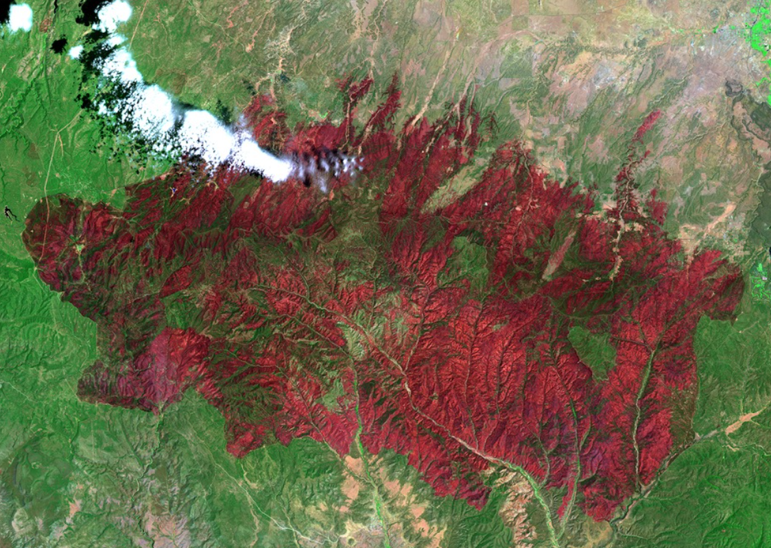
A case study of prescribed burns
Forest treatment was practiced before the fire outbreak, allowing for a case study to evaluate the impact of prescribed burns on forest recovery post-fire.
Area of Analysis
In this analysis, I compare four areas of no fire treatment (‘NoTreat 1-4’) to four pre-fire prescribed burn areas (‘Pre 1-4’). The prescribed burn areas are distinguished by their timing of fuel treatment before the fire. To evaluate differences, I applied remote sensing techniques.
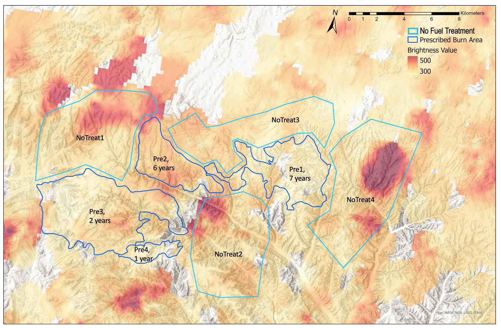
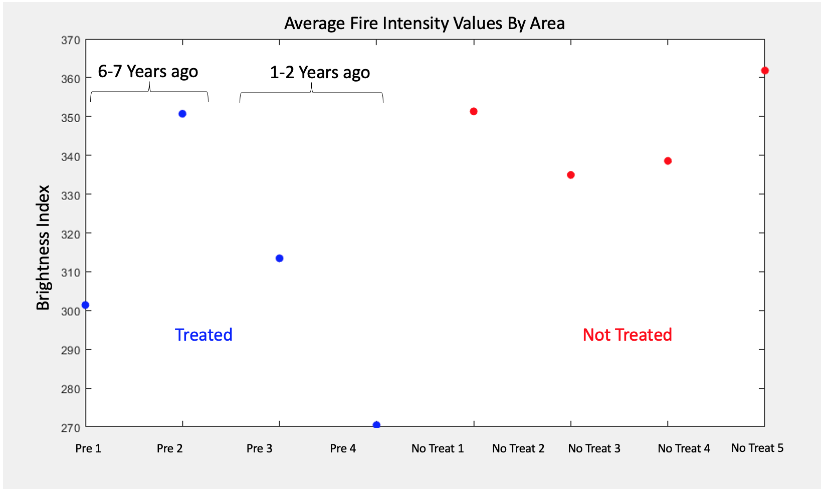
Comparing Burn Intensity
The ‘Brightness Index’ obtained from NASA’s MODIS sensor can be used to extract burn severity. A higher ‘Brightness Index’ corresponds to a higher burn severity.
Analysis reveals an overall trend that treated areas (e.g. prescribed burn areas) are associated with a lower-severity burn than untreated areas. These results are supported by previous research (Finney et al., 2005; Strom and Fule, 2007).
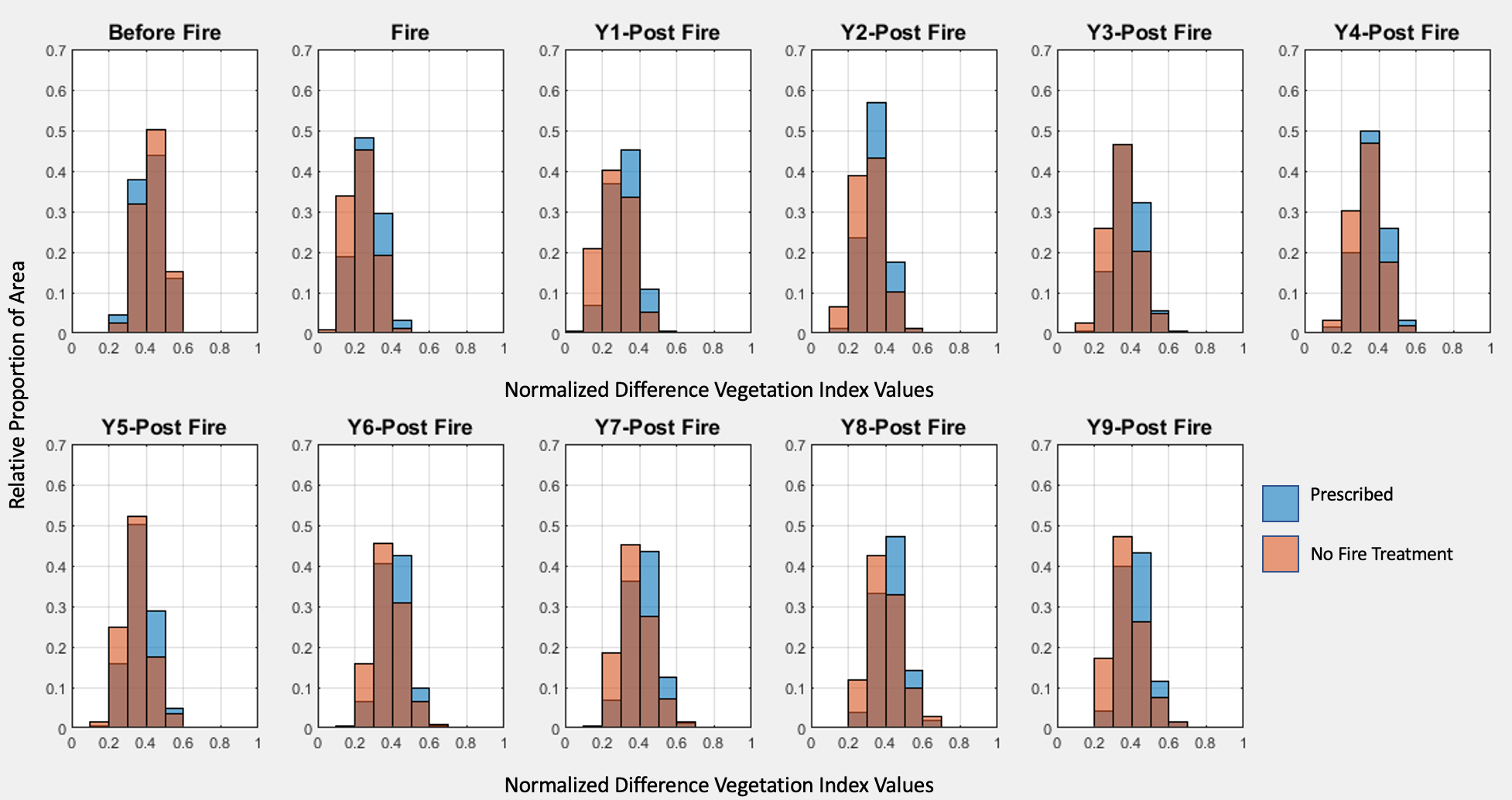
Comparing Vegetation Recovery Through the Normalized Difference Vegetation Index (NDVI)
The NDVI can provide insight into relative ‘greenness’ or vegetation health, with higher values generally indicating healthier vegetation.
A comparison of the relative proportion of area according to NDVI illustrates post-fire vegetation recovery.
Initially, areas with no fire treatment had a higher proportion of healthy vegetation (see ‘Before Fire’).
In the years following the fire (up to 9 years post-fire), treated areas (‘Prescribed’) consistently had a higher proportion of healthy vegetation.
This analysis suggests that prescribed burns are associated with lower-severity burns and therefore healthier vegetation in the long-term (>9 years).
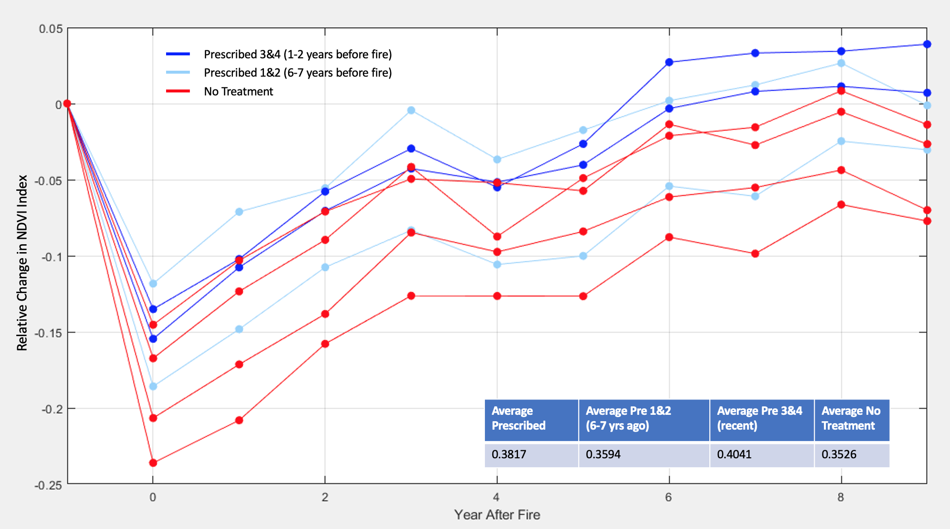
Comparing Post-Fire NDVI
On average, areas identified as ‘Prescribed Burns’ had healthier vegetation than areas without treatment.
The time since fire treatment, however, appears to make a difference. The average NDVI between areas treated 6-7 years pre-fire is not significantly different from those without fire treatments. Areas more recently treated (1-2 years pre-fire) have significantly higher average NDVI values. These conclusions are supported by Finney et al. (2005)’s findings.
Changes in Landcover
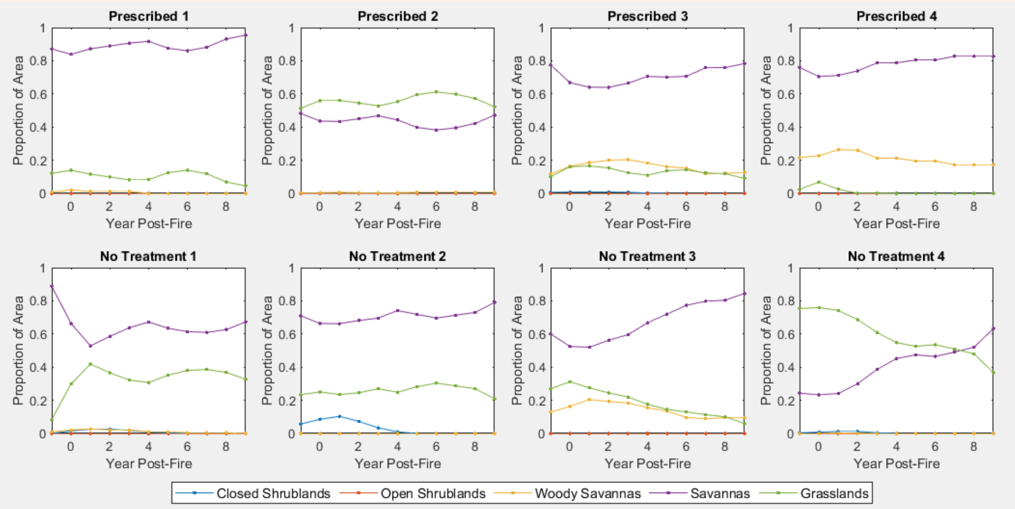
Landcover Classification was extracted from MODIS Terra and Aqua reflectance data at 250m resolution, and categorized according to the IGBP classification. The proportion area covered by each land classification was compared across the 8 analyzed areas.
Across almost all analyzed areas, the fire caused an initial decrease in Savannas and increase in Grasslands.
Analyses reveal variability in the dominant land cover across ‘Prescribed’ vs. ‘No Treatment’ areas. Whereas fluctuations do occur in ‘Prescribed’ areas, the proportions of landcover type in these areas are comparable pre-fire and 9 years post-fire.
‘No Treatment’ areas show more long-term changes in landcover type. This is especially evident in ‘No Treatment 4’–the area of highest burn intensity.
References
Finney, M., McHugh, C., & Grenfell, I. (2005). Stand- and landscape-level effects of prescribed burning on two Arizona wildfires. Canadian Journal of Forest Research, 35(7).
Ffolliott, P., & Neary, D. (2003). Initial Assessment of the Rodeo-Chediski Fire Impacts on Hydrologic Processes. Hydrology and Water Resources in Arizona and the Southwest, 1–7.
Ffolliott, P., Stropki, C., Chen, H., & Neary, D. (2011). The 2002 Rodeo-Chediski Wildfire’s impacts on southwestern ponderosa pine ecosystems, hydrology, and fuels. U.S. Department of Agriculture, Forest Service, Rocky Mountain Research Station, 36.
Strom, B., & Fule, P. (2007). Pre-wildfire fuel treatments affect long-term ponderosa pine forest dynamics. International Journal of Wildland Fire, 16, 128–138.